
Dubai Green Metro Line: Route, Stations, Timings, Map, Fares and Complete Travel Guide
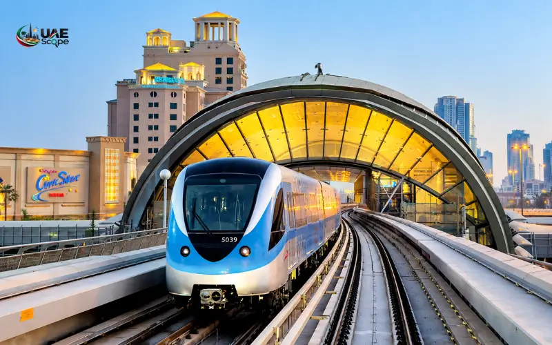
One of the key metro lines in Dubai that facilitates its residents and tourists to move from one point to another in the city is the Dubai Green Metro Line. It links key neighbourhoods, heritage neighbourhoods, and popular destinations and provides quick, cheap, and convenient access to Dubai. The line is a critical component of Dubai’s public transport infrastructure, contributing to a more efficient transportation experience for residents and visitors alike. The Dubai Green Metro Line route, stations, and main characteristics help you understand the line better and plan accordingly, whether you are a resident, tourist, or first-time visitor. It offers a safe link between various sections of Dubai and makes travel easier, more comfortable, and more convenient for all Dubai residents.
What Is the Dubai Green Metro Line?
Dubai Green Metro Line is one of the two existing Metro Lines in Dubai. It was introduced to enhance connectivity between the densely populated residential areas and the key commercial and cultural centres.
The route was planned with some of the best-known communities in Dubai as its base points, particularly those that are close to the Dubai Creek area, from where the city’s trading history has emerged.
The Green Line is the link between:
- Residential areas in northern Dubai.
- Traditional markets
- Historic districts
- Healthcare facilities
- Government offices
- Tourist attractions
The line is both underground and overground, so that people may move between areas that had previously relied heavily on road transport.
The Green Line is particularly favored by travellers to and from the following destinations:
- Gold Souq
- Spice Souq
- Al Fahidi Historical Neighbourhood
- Dubai Creek
- Bur Dubai markets
- Dubai Healthcare City
Dubai Green Metro Line Route
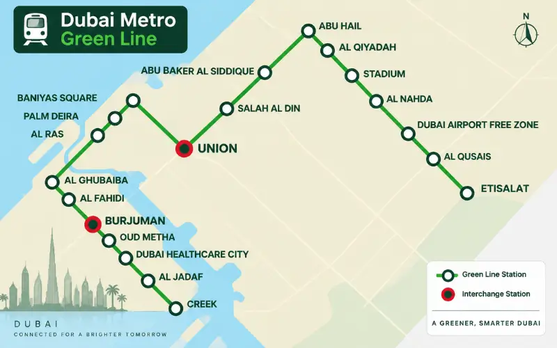
The route of the Dubai Green Metro Line is from the north of Dubai to the east near Dubai Creek.
The trip begins at:
e& Metro Station (G11)
This is the northern end station of the Green Line in Al Qusais.
The way then passes through significant zones such as:
- Al Qusais
- Dubai Airport Free Zone, Dubai, UAE.
- Al Nahda
- Deira
- Union
- Gold Souq
- Al Ras
- Bur Dubai
- Oud Metha
- Dubai Healthcare City
- Al Jaddaf
The final stop is:
Creek Metro Station (G30)
Creek Station is situated in Al Jaddaf and serves passengers to the Dubai Creek waterfront and marine transport services in the area.
Dubai Green Metro Line Stations List
The Green Line runs between e& and Creek with 20 stations in between.
| Code | Station Name | Area |
| G11 | e& | Al Qusais |
| G12 | Al Qusais | Al Qusais |
| G13 | Dubai Airport Free Zone | DAFZA |
| G14 | Al Nahda | Al Nahda |
| G15 | Stadium | Al Qusais |
| G16 | Al Qiyadah | Al Twar |
| G17 | Abu Hail | Abu Hail |
| G18 | Abu Baker Al Siddique | Deira |
| G19 | Salah Al Din | Deira |
| G20 | Union | Deira |
| G21 | Baniyas Square | Deira |
| G22 | Gold Souq | Deira |
| G23 | Al Ras | Deira |
| G24 | Al Ghubaiba | Bur Dubai |
| G25 | Sharaf DG | Bur Dubai |
| G26 | BurJuman | Bur Dubai |
| G27 | Oud Metha | Oud Metha |
| G28 | Dubai Healthcare City | Healthcare City |
| G29 | Al Jaddaf | Al Jaddaf |
| G30 | Creek | Al Jaddaf |
Dubai Green Metro Line Map and Interchange Stations
Dubai Metro network is designed to allow passengers to transfer between the lines easily.
The Green Line links to the Red Line at two key stations:
Union Metro Station
Union Metro Station is one of the key interchange stations of Dubai Metro.
Passenger transfers are available and made possible between:
- Green Line
- Red Line
It provides access to major areas in Deira and central Dubai.
BurJuman Metro Station
Located in Bur Dubai, BurJuman Station also connects:
- Green Line
- Red Line
This interchange can be helpful for commuters who want to go from Old Dubai to the western areas of Dubai.
Dubai Green Metro Line Timings
The Roads and Transport Authority (RTA) is responsible for the Dubai Metro operating schedule, which can be adjusted during public holidays, Ramadan, and events.
The timetable information on the RTA website indicates that train services are provided on the Green Line between E11 (G11) and Creek (G30), with RTA publishing daily timetables. Please refer to the latest timetable before travelling.
General operating schedule
| Day | Approximate Timing |
| Monday to Thursday | Early morning until midnight |
| Friday | Extended service hours |
| Saturday | Early morning until midnight |
| Sunday | Morning opening with evening service |
Passengers should always check the departure times via official RTA Dubai sources for accurate information.
Dubai Green Metro Line Fares and Nol Card
No traditional paper tickets can be bought by passengers to travel in Dubai Metro. The Nol Card is Dubai’s public transport payment system, and it is used to pay for travel.
The Nol Card is valid on:
- Dubai Metro
- Dubai Tram
- Public buses
- Marine transport services
There are zones that determine the fare charged in Dubai Metro.
The main fare structure is based on:
- Number of zones crossed
- Nol Card type
- Passenger category
If you commute regularly, it can be very convenient to have your own Nol Card.
Best Places to Visit Near Dubai Green Metro Line
One of the key benefits of the Green Line is that it links Dubai’s heritage sites.
Gold Souq Metro Station
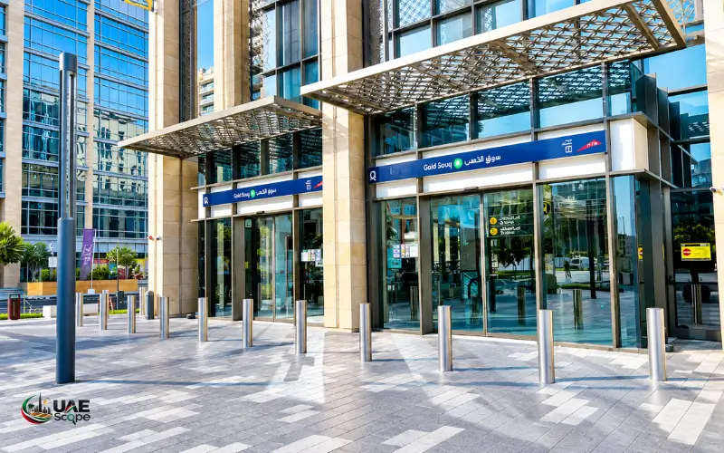
The Gold Souq Station is perfect for all visitors to explore:
- Dubai Gold Souq
- Traditional jewellery markets
- Deira shopping streets
This is an area reflecting Dubai’s heritage as a regional trading hub.
Al Ras Metro Station
Al Ras is one of Dubai’s oldest districts.
Nearby attractions include:
- Spice Souq
- Dubai Creek waterfront
- Traditional markets
One of the best places to enjoy history in Dubai.
Al Ghubaiba Metro Station
This station gives entry to:
- Al Ghubaiba Bus Station
- Dubai Creek
- Heritage attractions
- Marine transport connections
Sharaf DG Metro Station
This is the area near the old Al Fahidi Station:
- Al Fahidi Historical Neighbourhood
- Museums
- Old Dubai culture hotspots
Dubai Healthcare City Metro Station
This station is located in one of the biggest healthcare districts in Dubai.
Nearby locations include:
- Medical institutions
- Healthcare facilities
- Wafi City
Creek Metro Station
At the end of the Green Line station, you can get on to:
- Dubai Creek
- Al Jaddaf area
- Marine transport connections
Dubai Green Metro Line vs Red Metro Line
| Feature | Green Line | Red Line |
| Main Areas | Old Dubai, Deira, Bur Dubai | Downtown, Marina, Sheikh Zayed Road |
| Length | About 22.5 km | Longer citywide route |
| Stations | 20 | 35 |
| Best For | Heritage areas and central communities | Business districts and major attractions |
| Interchange | Union, BurJuman | Union, BurJuman |
Why Dubai Green Metro Line Is Important
Dubai’s Green Line has a significant importance in the transportation system.
Connecting Historic Dubai
The route connects the places where Dubai’s modern identity originated, particularly the Dubai Creek, Deira and Bur Dubai areas.
Reducing Road Congestion
The metro offers a viable alternative to private transport and lessens the strain on Dubai’s road infrastructure.
Supporting Tourism
Tourists can utilize both traditional markets and heritage sites without relying on taxis for all of them.
Improving Daily Commuting
The Green Line serves thousands of residents to access places of work, schools, healthcare providers and shopping areas.
Future of Dubai Metro and Green Line Connectivity
Dubai is still investing in public transportation facilities. Future developments are planned in the metro to increase the connectivity in the emirate.
Dubai’s rail network is further enhanced by the upcoming Dubai Metro Blue Line that is anticipated to open an additional major route, offering connectivity to other communities.
The Green Line will remain a key link between established neighbourhoods and future transport links.
Conclusion
The Dubai Green Metro Line is an essential part of Dubai’s modern transportation system, offering a convenient and reliable way to travel across the city. It links key communities, heritage sites, and everyday commuting areas and enhances the accessibility of public transport for both residents and visitors. The Green Line is poised to play a significant role in advancing Dubai’s smart and sustainable city goals with its streamlined service, seamless connectivity, and integration with other Dubai transportation modes. From commuting to work, visiting Dubai sightseeing, or for daily activities, this metro route is one of the easiest and most convenient ways to explore and move around Dubai.
Also Read: Shahama Bus Station: Routes, Timings, Location & Travel Guide
Frequently Asked Questions
What is the Dubai Green Metro Line?
Dubai Green Metro Line is one of the two major lines of Dubai Metro that will travel from E & Station in Al Qusais to Creek Station in Al Jaddaf in the course of the city.
How many stations are on Dubai Green Metro Line?
The Green Line has 20 stations that cover an overall distance of around 22.5 kilometres.
Where does the Dubai Green Metro Line start and end?
The line starts at Emaar Metro Station (G11) and ends at Creek Metro Station (G30).
Does the Green Line connect with the Red Line?
Yes. There are two transfer stations between the Green Line and Red Line: Union Station and BurJuman Station.
Which Green Line station is closest to Gold Souq?
Gold Souq Metro Station (G22) is located next to the Gold Souq area in Deira.
Can tourists use Dubai Green Metro Line?
Yes. With a valid Nol Card, tourists can ride the Green Line.
Is Dubai Creek connected to Green Metro Line?
Yes. Green Line’s eastern end station is Creek Metro Station (G30).
Is Dubai Airport connected to Green Metro Line?
The Green Line provides transport service to locations around Dubai International Airport, including Dubai Airport Free Zone. Individuals traveling, they should know the best way to travel according to their terminal.
Which areas does Green Line cover?
The Green Line goes to Al Qusais, Deira, Bur Dubai, Oud Metha, Dubai Healthcare City, Al Jaddaf, and Creek.